
Zip code targeting is a form of geographic targeting that shows your ads to people in specific postal-code areas — whether they live there, recently visited, or have shown interest in that area. Platforms like Google Ads, Meta Ads Manager, and Foursquare all support it. If you run a restaurant, a delivery service, or any local business where geography directly affects revenue, this is one of the sharpest tools in your paid media kit.
Three reasons to use it right now:
- 🎯 Efficiency — your budget concentrates on the neighborhoods most likely to convert, not a broad metro radius
- 📍 Relevance — ads feel local because they are local, which lifts click-through and conversion rates
- 📊 Measurable lift — you can isolate performance by ZIP and run clean geo-experiments to prove what’s working
Key Takeaways
Zip code targeting concentrates your ad budget on the specific postal-code areas where your best customers live, order, and make dining decisions — making every dollar work harder than a broad city or radius campaign.
| Point | Details |
|---|---|
| ZIP vs. radius vs. geofence | Use ZIP lists for multi-zone coverage and delivery areas; use geofencing for real-time, moment-of-decision triggers. |
| Validate before launch | Check every ZIP for platform recognition and exclude PO-box-only codes before your campaign goes live. |
| Measure with geo-lift tests | Run test and holdout ZIPs simultaneously to calculate true incremental lift, not just campaign-level conversions. |
| Brief your agency with data | Bring POS order ZIPs, delivery platform data, and Census ZCTA overlays to your agency brief for a faster, smarter pilot. |
| Ionhospitality | Ionhospitality manages ZIP-targeted campaigns for restaurants end-to-end, from ZIP selection to weekly optimization, with no commissions. |
Table of Contents
- What zip code targeting is and where it fits inside geotargeting
- How ad platforms decide who is “in” a ZIP code
- Platform-specific setup highlights and limitations
- Common business use cases and real-world examples
- When to use ZIP codes vs. radius targeting vs. geofencing
- Campaign best practices and common mistakes to avoid
- How to measure performance and run valid tests
- How restaurants should brief an agency on ZIP-targeted campaigns
- Legal, privacy, and platform policy considerations
- What running these campaigns actually teaches you
- Ionhospitality runs geo-targeted campaigns that fill seats and book events
- Sources
What zip code targeting is and where it fits inside geotargeting
Geotargeting is the broad category. Zip code targeting is one specific method inside it — you define your audience by a list of postal codes rather than a radius drawn around a pin or a real-time geofence boundary.
Think of geographic precision as a ladder:
- Country/State → broadest reach, lowest relevance
- City/DMA → useful for brand awareness
- ZIP code → neighborhood-level precision, static list-based
- Geofence → real-time boundary trigger, device-level
- Device/individual → hyper-precise, highest privacy sensitivity
ZIP-level targeting sits in the sweet spot for most local businesses. It’s more precise than city targeting and far easier to manage at scale than individual geofences. The tradeoff: it’s static. You define the list upfront, and the platform serves to anyone the system places inside those codes — it doesn’t react in real time to where a device physically is at this exact moment.
Quick comparison:
| Method | Precision | Real-time? | Best for |
|---|---|---|---|
| Radius/proximity | Medium | No | Single-location walk-in traffic |
| ZIP code list | Neighborhood | No | Multi-zone coverage, delivery areas |
| Geofencing | High | Yes | Moment-of-decision, geo-conquesting |
| City/DMA | Low | No | Brand awareness, broad reach |
How ad platforms decide who is “in” a ZIP code
Platforms don’t just look at where your phone is sitting right now. They layer multiple signals to infer postal-code membership, and that inference is imperfect by design.
Primary signals platforms use:
- Device GPS — the most accurate signal, used heavily in mobile apps that have location permissions
- IP-to-postal mapping — your internet connection’s IP address is mapped to an approximate location; accuracy degrades in rural areas and with VPNs
- Wi-Fi positioning — nearby networks help triangulate location, especially indoors
- User-declared address — billing address, shipping address, or profile location entered by the user
- Location history and search behavior — past visits, search queries, and content consumption patterns
This last category is where things get interesting. Google Ads may serve your ad to someone whose physical location is outside your target ZIP if the platform infers they have a “location of interest” there — meaning they searched for businesses in that area, have a history of visiting it, or the content they’re consuming signals intent toward it. That’s a feature, not a bug, for most campaigns. A person in ZIP 10001 searching for “best Italian restaurant 10003” is a valid target for a restaurant in 10003.
Where accuracy breaks down:
- Rural ZIPs cover large geographic areas, so IP mapping is less precise
- PO-box-only ZIPs have no residential population and most platforms won’t serve to them
- IP addresses assigned by mobile carriers often resolve to a carrier hub, not the user’s actual location
Expect some mismatch between your target list and actual impressions. That’s normal. The practical move is to monitor your geographic performance report and exclude ZIPs that consistently underperform.
Platform-specific setup highlights and limitations
🔵 Google Ads
Google Ads supports postal-code targeting with a few critical setup details you need to get right before launch.
Setup checklist:
- In your campaign settings, go to Locations and select “Enter another location.”
- Search by postal code — always include the country qualifier (e.g., “10001, United States”) to avoid ambiguity.
- For bulk imports via spreadsheet, preserve leading zeros (ZIP codes like 01001 will drop the leading zero in Excel unless the column is formatted as text).
- Set your Advanced Location Options to “People in or regularly in your targeted locations” for standard campaigns, or switch to “People in your targeted locations” if you want strict physical-presence matching.
- Check privacy thresholds — Google will not serve to a location if the audience is too small to meet its minimum user count requirements.
Pro Tip: *Run a geographic performance report weekly.
🔵 Meta Ads Manager
Meta lets you target by postal code with three location-type options that change who sees your ad significantly:
- People who live here — uses declared home location and behavioral signals
- People recently in this location — anyone whose device was detected in the ZIP recently
- People traveling in this location — visitors, not residents
For most restaurant campaigns, “People who live here” or “People recently in this location” will outperform the traveling option. Combine postal-code targeting with interest or behavioral layers (e.g., people interested in dining out) to sharpen relevance without shrinking reach too aggressively.
Pro Tip: Upload a creative version that references the neighborhood by name — “Hey, [Neighborhood Name] — your table is ready.” Hyper-local copy consistently outperforms generic ad copy in Meta campaigns targeting tight ZIP lists.
🔵 Microsoft Advertising / Xandr
Microsoft and Xandr support postal-code lists with include and exclude functionality, and in the U.S. you can target down to ZIP+4 (the full nine-digit code) for even finer precision. One important caveat: some legitimate postal codes won’t appear as targetable in the UI until the platform has associated device IP activity with them. If a ZIP you need isn’t recognized, it’s not necessarily invalid — it may just lack sufficient device data in Microsoft’s network yet.
Setup checklist:
- Build your postal-code list in the Xandr UI under Inventory > Postal Code Lists.
- Save the list as a reusable asset — you can apply it across multiple campaigns and deals without rebuilding it each time.
- Use the exclude list to block ZIPs outside your delivery area or service boundary.
- Validate each ZIP before launch by checking recognition in the UI.
🔵 Programmatic DSPs and Foursquare
Programmatic platforms let you upload postal-code lists as targeting segments and apply them across display, video, and native inventory. The efficiency gain here is list reuse: build your delivery-area ZIP list once and apply it to every campaign that shares that coverage zone.
Foursquare draws a clear line between geotargeting (reaching audiences based on where they regularly go) and proximity geofencing (triggering ads when a device crosses a real-time boundary). For ZIP-level campaigns, you’re in geotargeting territory. For geo-conquesting — placing ads in front of people who are physically at a competitor’s location right now — you need geofencing. Both tactics can run simultaneously in a well-structured programmatic campaign.
Common business use cases and real-world examples
ZIP-level targeting works across a wide range of local business objectives. Here’s where it consistently delivers:
-
Delivery-area promotions — A restaurant defines its delivery radius as a set of ZIPs and runs ads only in those codes, promoting a limited-time free-delivery offer. The campaign objective is online orders, and every dollar stays inside the serviceable area. Pair this with local food delivery strategy to align your offer with what customers in those ZIPs actually expect.
-
Neighborhood grand openings — A new location targets the five ZIPs surrounding the address for two weeks before and two weeks after opening day. Objective: foot traffic and brand awareness. Expected KPI: cost per store visit or cost per new customer acquisition.
-
Private event and catering promotions — A full-service restaurant targets high-income ZIPs within a 10-mile radius with ads promoting private dining rooms and catering packages. Objective: event inquiry form submissions.
-
Field-service routing — A home-services company targets only the ZIPs its crews are scheduled to work in that week, reducing drive time and increasing booking density per route.
-
Geo-conquesting — A restaurant targets ZIPs where competitor locations are clustered, serving ads to people who regularly visit those areas. Per Foursquare’s location targeting guide, geo-conquesting captures high-intent consumers at the exact moment they’re deciding where to eat or shop.
-
Cross-channel direct mail activation — You mail a physical offer to households in three ZIPs and simultaneously run digital ads in those same codes. The combined exposure lifts response rates compared to either channel alone.
Industries that use ZIP-level targeting most: restaurants, quick-service chains, retail boutiques, home services (HVAC, plumbing, landscaping), healthcare clinics, and real estate.
When to use ZIP codes vs. radius targeting vs. geofencing
The right method depends on your business model, not just your preference. Use this decision framework:
Choose ZIP code lists when:
- Your service area maps to specific neighborhoods or delivery zones
- You want to run the same list across multiple campaigns without rebuilding it
- You need to include some areas and explicitly exclude others (e.g., exclude a ZIP where you don’t deliver)
- You’re doing a neighborhood rollout for a chain and need clean, auditable coverage zones
Choose radius targeting when:
- You have a single physical location and want to reach everyone within a drive or walk
- Your audience is defined by proximity to your store, not by where they live
- You’re running a simple awareness campaign and don’t need ZIP-level reporting granularity
Choose geofencing when:
- You want real-time triggers — ads that fire when someone physically enters a boundary
- You’re running geo-conquesting around competitor locations
- You need moment-of-decision targeting (e.g., someone standing in a shopping center)
Mixing methods: ZIP lists and geofencing work well together. Use your ZIP list for broad coverage across your trade area, and layer a geofence around your own location (or a competitor’s) to capture high-intent moments. The ZIP list handles reach; the geofence handles conversion timing.
A delivery-only restaurant almost always benefits more from radius or ZIP targeting than from geofencing — the customer doesn’t need to be near you to order. A dine-in restaurant running a lunch promotion, on the other hand, can use a geofence around nearby office buildings to catch the 11:45 AM “where should we eat?” decision.
Campaign best practices and common mistakes to avoid
✅ Do this:
- Validate ZIP availability before launch. Check that every code on your list is recognized by the platform. Unrecognized ZIPs silently drop from targeting without warning.
- Use both inclusion and exclusion lists. Include your target ZIPs; exclude ZIPs outside your service area or where your offer doesn’t apply.
- Localize your creative. Reference the neighborhood, a local landmark, or a community event. Generic creative underperforms in tight geographic campaigns.
- Align bidding to ZIP-level performance. After 30 days, raise bids in your top-converting ZIPs and reduce or pause spend in underperformers.
- Exclude PO-box-only ZIPs. Most platforms won’t serve ads to PO-box-only postal codes — target the surrounding residential ZIP instead.
❌ Don’t do this:
- Don’t target extremely small ZIPs without testing first. Tiny ZIPs may not meet platform privacy thresholds, resulting in zero impressions.
- Don’t rely on ZIP targeting alone for attribution. ZIP-level data tells you where impressions went, not definitively who converted. Layer in conversion tracking and geo-lift tests.
- Don’t ignore leading zeros in bulk imports. ZIP codes starting with 0 (New England states, for example) will corrupt silently in Excel unless the column is text-formatted.
- Don’t set it and forget it. ZIP-level performance shifts with seasons, local events, and competitor activity. Review weekly.
Pro Tip: Overlay Census Bureau ZCTA demographic data on your ZIP list before finalizing it. ZIP Code Tabulation Areas from the Census Bureau give you household income, age distribution, and population density — all free. Cross-reference with your POS data to find ZIPs where your existing customers already live, then prioritize those.
How to measure performance and run valid tests
Good measurement at the ZIP level requires more than checking your campaign dashboard. Here’s a practical testing framework:
Core KPIs to track:
- Click-through rate (CTR) by ZIP
- Cost per click (CPC) by ZIP
- Conversion rate (orders, bookings, form submissions) by ZIP
- Cost per incremental visit (for foot-traffic campaigns)
- Geo lift: incremental conversions in targeted ZIPs vs. holdout ZIPs
Running a geo lift test:
- Select your test and holdout ZIPs. Choose ZIPs that are demographically similar but geographically separated enough that ad spillover is minimal.
- Run ads only in test ZIPs for the campaign period. Keep holdout ZIPs dark.
- Measure the difference in conversion rate (or store visits) between test and holdout groups at the end of the period.
- Calculate incremental lift — the percentage increase in conversions attributable to the campaign, not to baseline behavior.
- Check for statistical significance before drawing conclusions. Small ZIPs with low traffic volumes need longer test windows to generate reliable data.
Reporting cadence:
- Daily: ad health check (spend pace, impressions, any disapprovals)
- Weekly: performance by ZIP (CTR, CPC, conversions, top and bottom performers)
- Monthly: geo-lift summary, budget reallocation decisions, ZIP list refinement
Fold ZIP-level learnings back into your audience strategy. High-converting ZIPs become the seed for lookalike audiences. Underperforming ZIPs get excluded or deprioritized in the next campaign cycle. This feedback loop is what separates a one-time campaign from a compounding local marketing program.
How restaurants should brief an agency on ZIP-targeted campaigns
If you’re handing this off to an agency, a clear brief saves weeks of back-and-forth. Here’s a template built for restaurant campaigns:
Campaign brief fields:
- Objective — foot traffic, online orders, private event inquiries, or catering leads
- Target ZIP list — how it was selected (POS order data, delivery platform ZIPs, trade-area analysis, or Foursquare POI data)
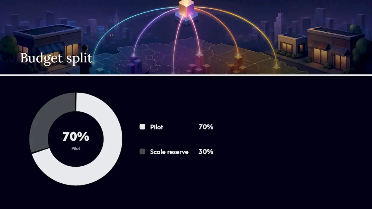
- Budget — total and split between pilot and scale phases (recommended: 70% pilot, 30% held for scaling winners)
- Timing — campaign start/end dates, any blackout periods, seasonal peaks
- Creative assets — photos, video, offer details, neighborhood-specific copy variants
- Offer details — discount, event, new menu item, or limited-time promotion
- Measurement goals — primary KPI, secondary KPIs, attribution window
- Reporting cadence — daily health, weekly by-ZIP performance, monthly geo-lift summary
ZIP selection sources to pull from:
- Your POS system’s customer address or order ZIP data
- Delivery platform (DoorDash, Uber Eats) order origin ZIPs
- Census Bureau ZCTAs for demographic overlays
- Foursquare or similar POI data for foot-traffic patterns
- First-party reservation data (OpenTable, Resy) showing guest home ZIPs
Sample pilot timeline:
- Week 1–2: ZIP validation, creative production, campaign setup
- Week 3–6: Pilot campaign live in test ZIPs; holdout ZIPs dark
- Week 7: Performance review, geo-lift calculation, ZIP list refinement
- Week 8+: Scale budget into winning ZIPs, pause or exclude underperformers
A well-run pilot on a modest budget tells you exactly which ZIPs to double down on. That’s the data an agency like Ionhospitality uses to build campaigns that fill seats and drive bookings rather than just generate impressions.
Legal, privacy, and platform policy considerations
ZIP-level targeting is legal and widely used, but platform policies and privacy expectations create real constraints you need to plan around.
Privacy basics:
- Apps must obtain user consent for precise location data before that signal can be used for ad targeting
- Platforms enforce minimum population and user-count thresholds — if a ZIP is too small, it won’t be targetable regardless of what you enter
- Google Ads enforces privacy thresholds and radius minimums that prevent targeting audiences below a certain size, protecting individual user anonymity
Platform policy callouts:
- Google: Won’t serve to locations that fall below its minimum user-count threshold; advanced location options must be set deliberately or the default may include “location of interest” matches you didn’t intend
- Meta: Minimum location size applies; very small ZIPs may be unavailable or combined with adjacent areas
- Microsoft/Xandr: Some postal codes are unrecognized until IP activity associates devices with them — validate before launch
Practical compliance steps:
- Use aggregated geographic reporting rather than individual-level location data in your own records
- Avoid using ZIP targeting as a proxy to target sensitive categories (health conditions, religion, political affiliation) by area — platforms prohibit this and it creates legal exposure
- Document your ZIP selection methodology and data sources, especially if you’re using third-party data providers
- Set a data retention policy for any location-based audience lists you build
The rule of thumb: target neighborhoods, not individuals. ZIP-level targeting is designed for exactly that, which is why it sits comfortably within platform policies when used as intended.
What running these campaigns actually teaches you
Most guides on ZIP-level targeting focus on setup. What they skip is the insight layer — what you learn after the campaign runs that changes how you market forever.

When you run a properly structured geo-lift test across a set of ZIPs, you stop guessing which neighborhoods your best customers come from. You know. That data reshapes everything: where you invest in local partnerships, which neighborhoods get a direct mail drop, where you open your next location. Restaurants that treat ZIP-level campaign data as a business intelligence asset — not just an ad metric — end up with a compounding advantage over competitors who reset to zero with every campaign.
The other thing most operators underestimate: exclusion lists matter as much as inclusion lists. Knowing which ZIPs don’t convert for your offer is just as valuable as knowing which ones do. A ZIP that looks demographically attractive on paper but consistently underperforms in your campaigns is telling you something real about fit. Trust the data over the assumption.
Ionhospitality runs geo-targeted campaigns that fill seats and book events
Ionhospitality builds and manages geo-targeted ad campaigns for full-service restaurants — ZIP selection, creative production, platform setup, and weekly optimization, all done for you with no commissions on your orders or bookings.
Where most agencies hand you a dashboard and a monthly report, Ionhospitality starts with your POS data and delivery ZIPs to build a target list grounded in your actual customer geography. The pilot is structured to generate real geo-lift data, not just impressions. You’ll know within 30 days which ZIPs are worth scaling and which to cut.
Ready to scope your first ZIP-targeted campaign? Book a discovery call and we’ll map your delivery area, identify your highest-value ZIPs, and outline a pilot budget and timeline in one conversation.
Sources
Official platform documentation and authoritative resources for ZIP-level campaign setup:
- Location-Based Targeting: The Complete Guide to Audience & Geofencing | Foursquare
- Create postal code lists – Microsoft / Xandr docs
- ZIP Code Tabulation Areas (ZCTAs) – U.S. Census Bureau

Add a Comment